Gower Pilgrimage Way : Cycle Route Directions
Total Distance : 42 miles
When you have finished your cycle ride, we would be extremely grateful if you would complete a very short survey (2 minutes) by clicking HERE.
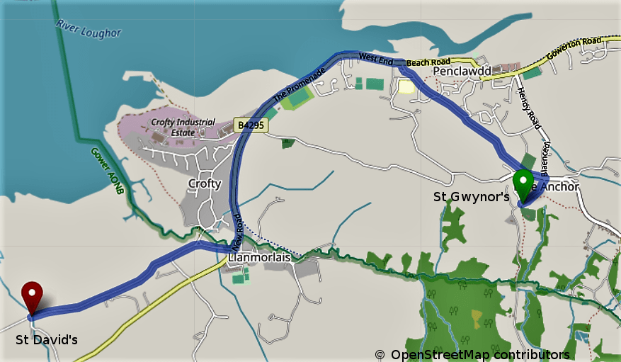
Penclawdd to Wernffrwd (St Gwynour to St David)
Section length: 3.01 miles Time: 18 minutes
© OpenStreetMap contributors
- From the Church gate at St Gwynour, go right onto Church Lane and then left onto Blue Anchor Road then right onto Victoria Road which is a steep descent.
- At 0.9 miles TJ (T Junction), turn left onto the B4295 SP (Sign Post) Crofty.
- At 1.70 miles, turn right onto Pencaerfenni Lane, keep right onto Forge Road and keep right at 2.18 miles onto the Marsh Road.
- At 3.01miles, arrive at St David’s Church on the left.
Wernffrwd to Llanrhidian (St David to St Rhydian & St Illtyd)
Section length: 1.85 miles Time: 11 minutes

- From St David’s Church, continue on the Marsh Road toward Llanrhidian.
- Follow the road onto Mill Lane and past the Welcome Inn on the left going up the hill.
- At 1.85 miles, arrive at St Rhydian’s Church on the Right.
Llanrhidian to Cheriton (St Rhydian to St Cadoc)
Section length: 3.41 miles Time: 21 minutes

- From St Rhydian’s Church, continue up the hill for 0.81m to the TJ with the B4295. Turn right SP Llangennith.
- At 0.94 miles, at Oldwalls, turn right on the fork, follow this road to Cheriton.
- There is a steep descent into Cherition, at 3.41 miles, arrive at St Cadoc’s Church on the right.
Cheriton to Llanmadoc (St Cadoc to St Madoc)
Section length: 0.81 miles Time: 5 minutes
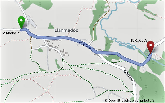
- From St Rhidian’s Church, continue through the village of Cheriton, go past the Britannia Inn on the right.
- Continue up the steep hill and through the village of Llanmadoc.
- At 0.81 miles, arrive at St Madoc’s Church.
Llanmadoc to Llangennith (St Madoc to St Cenydd)
Section length: 3.10 miles Time: 18 minutes

- From St Madoc’s Church, reverse direction and go back to the bottom of the steep hill near the Britannia Inn, turn right up the steep hill on Kyfts Lane. Keep on this road until a TJ
- At 1.63 miles, turn right at the TJ, SP Llangennith.
- Continue to the bottom of the steep decent until the Kings Head on the right at Llangennith. The Church is opposite the pub.
- At 3.1 miles, arrive at St Cenydd’s Church on the left.
Llangennith to Reynoldston (St Cenydd to St George)
Section length: 3.96 miles Time: 24 minutes
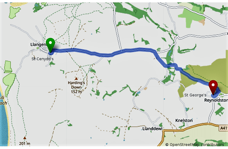
- From St Cenydd’s Church, return on the same road for 2.15 miles to Burry Green.
- At Burry Green, turn right SP Llanddewi.
- At 2.48 miles, keep left at the fork to Reynoldston, follow the road until 3.85 miles.
- At 3.85 miles, turn right at the Post Office onto Robbins Lane, at the bottom of this Lane there is a cross roads, turn right towards the Fire Station.
- At 3.96 miles, arrive at St George’s Church on the right.
Reynoldston to Llanddewi (St George to St David)
Section length: 1.79 miles Time: 12 minutes

- From St George’s Church, go back across the cross roads on Robbins Lane to the TJ, turn right and follow this road until the TJ with A4118.
- At the TJ, turn right SP Port Eynon.
- Follow the A4118 through Knelston
- At 1.47 miles, take a right turn SP Llanddewi.
- After approx. 250 yards, left turn SP St David’s Church
- At 1.79 miles, arrive at St David’s Church on the right.
Llanddewi to Rhossili (St David to St Mary)
Section length: 4.68 miles Time: 30 minutes
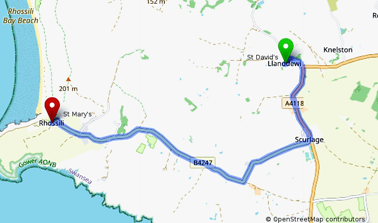
- From the Church, go back to the TJ with the A4118
- At 0.32 miles, turn right SP Port Eynon
- At 1.21 miles at Scurlage, turn right onto the B4247 SP Rhossili
- Continue on the B4247 to Rhossili
- At 4.68 miles, arrive at St Mary’s Church on the right.
Rhossili to Port Eynon (St Mary to St Cattwg)
Section length: 5.03 miles Time: 30 minutes

- From Rhossili, return on the B4247 for 3.5 miles to the TJ at Scurlage,
- At the TJ, turn right on the A4118 SP Port Eynon
- There is a steep descent into Port Eynon, at 5.03 miles, arrive at St Cattwg’s Church on the left.
Port Eynon to Penrice (St Cattwg to St Andrew)
Section length: 3.11 miles Time: 25 minutes

- From the Church go back on A4118 back up the hill for 0.9 miles.
- At 0.9 miles, Right turn SP Horton
- At 2.95 miles, left turn SP Penrice.
- At 3.11 miles, arrive at St Andrew’s Church on the Green on the right.
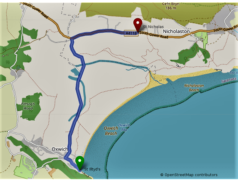
Penrice to Oxwich (St Andrew to St Illtyd)
Section length: 1.4 miles Time: 12 minutes

- From the Church, go left and back to the fork junction
- Keep left SP Oxwich, continue on this road descending into Oxwich.
- At 1.19 miles, at the cross roads in Oxwich Village, go straight on SP Oxwich Bay Hotel and Church.
- Go past the Hotel to the start of the footpath. Approx. 250 yards up the path, arrive at St Illtyd’s Church.
Oxwich to Nicholaston (St Illtyd to St Nicholas)
Section length: 2.17 miles Time: 15 minutes
- Go back past the Hotel to the cross roads in the village, turn right past the Dunes Gift Shop and continue up the steep hills to the TJ with the A4118 at 1.51 miles.
- At the TJ, turn right on the A4118
- At 2.17 miles, arrive at St Nicholas on the right.
Nicholaston to Penmaen (St Nicholas to St John)
Section length: 1.31 miles Time: 9 minutes
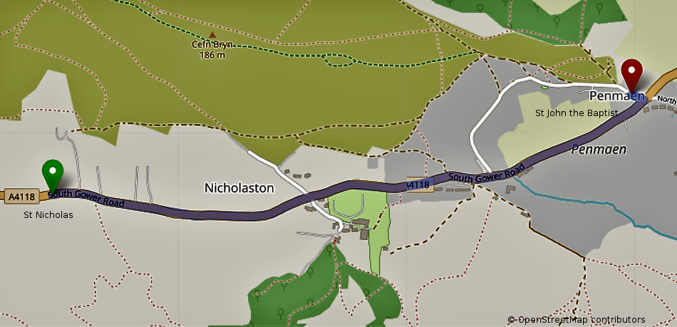
- From the Church, continue on the A4118 for 1.31 miles
- Arrive at St John’s Church on the left.
Penmaen to Ilston (St John to St Illtyd)
Section length: 2.04miles Time: 15 minutes
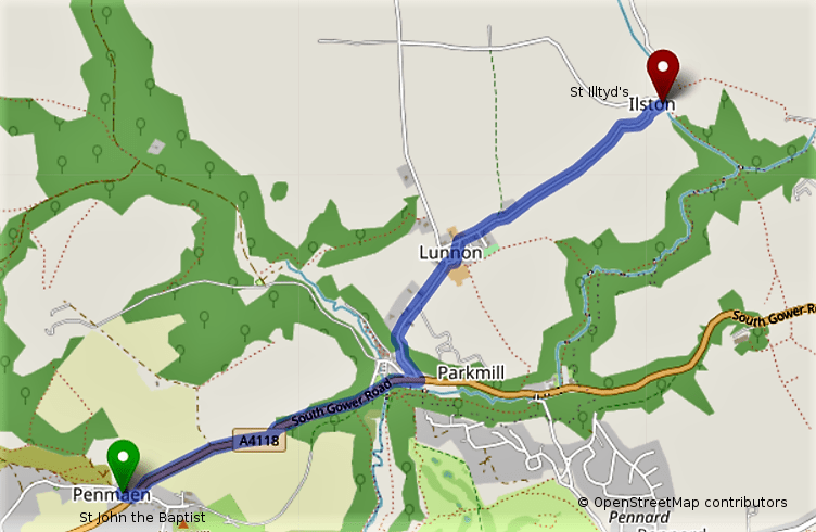
- From the Church, continue on the A4118 for 0.84 miles to Shepherds General Store.
- At Shepherds, turn immediate left up the very steep hill towards Lunnon
- At 1.27 miles, turn right SP Ilston and Lunnon
- At 2.04 miles, arrive at St Illtyd’s Church on the right over the stream.
Ilston to Pennard (St Illtyd to St Mary)
Section length: 3.1 miles Time: 20 minutes

- Return via Lunnon to TJ on A4118 at Shepherds 1.16 miles
- At the TJ with the A4118, turn left, past the Gower Inn on the left
- At 2.53 miles, turn right onto B4436 Vennaway Lane
- At 3.1 miles, arrive at St Mary’s Church on the right on the TJ with Pennard Road.
Pennard to Bishopston (St Mary to St Teilo)
Section length: 1.0 mile Time: 6 minutes

- From the Church and the TJ with the Pennard Road, turn left toward Kittle
- Just past the Beaufort Arms in Kittle, turn sharp right onto a narrow concealed road, Old kittle Road.
- Down the steep hill, there is a Ford, walk across the footbridge to the Church on the right.
