Route directions
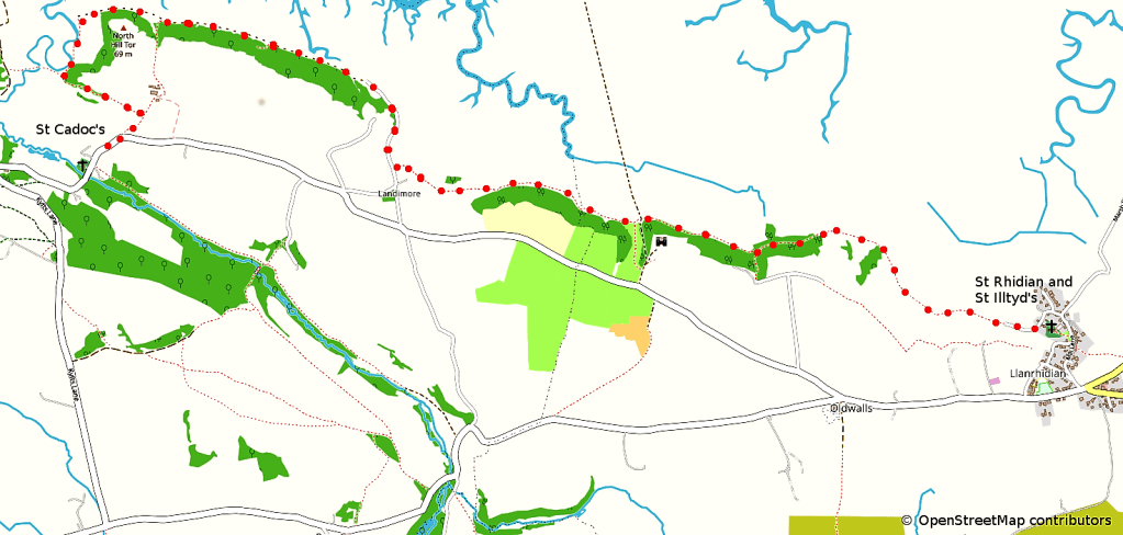
- Starting outside the church porch at Llanrhidian, turn right and walk through the churchyard to a stone stile at the end of the path. Cross over this stile and walk for around 50 yards to reach a minor road.
- Turn left and walk with care along this road, which is waymarked as being on the Wales Coast Path.
- After passing Staval Hager Farm on the right, the road becomes a track, and later a path
- Continue to follow the Wales Coast Path signs, ignoring other footpath signs to the left. The route passes Weobley Castle above you on the left, and there are magnificent views over the marsh, the Burry Estuary, and over to Whiteford Point and Pembrey.
- The Coast Path signs lead through the village of Landimore and National Trust land at Bovehill and then along the side of the marsh below North Hill Tor.
- On reaching the point where the Coast Path divides into a High Tide route and a Low Tide Route, take the High Tide route which turns left and leads up the hill towards Cheriton.
- The Coast Path signs lead to a lane, where you turn right and follow the lane to the road.
- At the road, turn right and walk carefully down the hill for around 100 yards to reach the church of St Cadoc at Cheriton on the right hand side.
If you are continuing on further on the Pilgrimage Way, please ignore the following request but if this is where you are finishing your pilgrimage, we would be extremely grateful if you would complete a very short survey (2 minutes) by clicking HERE.
