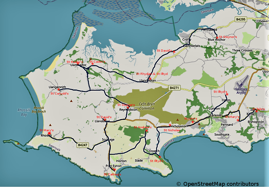
© OpenStreetMap contributors
The cycle route is approximately 42 miles long, split into 16 stages, each connecting two of the seventeen Anglican churches of Gower. The first few stages follow the picturesque salt marsh coast of North Gower before heading South to the more rugged landscape of South Gower dominated by limestone cliffs and sandy beaches. Much of the route is on quiet country roads but some sections involve the more major A4118 and B4247. In the holiday season these can be extremely busy and care should be taken. The Gower peninsula is mainly a plateau, 150–450 feet (45–140 metres) high, into which many short streams have incised narrow, steep-sided valleys. Inevitably, therefore, there will be a number of steep climbs and descents on the route.
The cycling route has been developed by Ian Davies, Secretary of the Swansea and West Wales branch of Cycling UK. Guide booklets containing maps and directions for both
the walking and cycling routes are available from The Lamplighter Café, 90 Bishopston Road,
Bishopston, SA3 3EN, and also from several of the churches along the route.
Some refreshment opportunities en route:
Llanrhidian: The Welcome Country Pub and Kitchen
Llanmadoc: The Britannia Inn, the Community Shop and the Cwm Ivy Cafe (just down the hill from the church
Llangennith: The King’s Head
Reynoldston: The King Arthur Hotel
Rhossili: The Lookout and The Worm’s Head Hotel
Port Eynon: The Ship Inn and The Smugglers Haunt
Oxwich: The Oxwich Bay Hotel and the Dunes Gift Shop
Perriswood Archery and Falconry Centre (near Nicholaston church)
Parkmill: The Gower Inn and Shepherd’s Shop
Bishopston: The New Gower Hotel
For detailed instructions for each stage together with maps, click HERE
For a more concise version of the instructions without maps, click HERE
